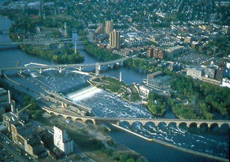
Saint Anthony Falls
|
|
Saint Anthony Falls, or the Falls of Saint Anthony, located near downtown Minneapolis, Minnesota, was the only waterfall on the Mississippi River until it was replaced by a concrete apron after they partially collapsed in 1869 and, later, a series of dams in the 1950s and 1960s. In the 17th century, the falls became known to the world beyond the indigenous people who lived in their vicinity when they were observed by Father Louis Hennepin, who also brought the existence of Niagara Falls to the world's attention. The region around the falls was added to the National Register of Historic Places as the Saint Anthony Falls Historic District in 1971.
Geologists say that the falls first appeared roughly 10,000 years ago several miles downstream around modern-day Saint Paul. The massive River Warren, a precursor of today's Minnesota River, had a waterfall that is said to have been twice as wide as Niagara Falls. Over the millennia, the falls moved upstream, breaking of into several smaller waterfalls as tributaries were reached. Minnehaha Falls in south Minneapolis is one of several such examples. The falls also gradually shrank, measuring only 16 feet in height by the time Minneapolis developed.
In the late 19th century, the falls were in danger of collapse due to the weakness of the underlying structure. At one point, a tunnel that was being dug under the upper part to supply water to nearby mills collapsed, creating a whirlpool that caused the downriver tip of nearby Nicollet Island to erode quickly. Dams were built above the falls and the surface of the falls was reinforced.
St. Anthony Falls was the upper limit of commercial navigation on the Mississippi until two dams and a series of locks were built between 1948 and 1963 by the United States Army Corps of Engineers. The locks make commercial navigation possible above Minneapolis but, since the locks in Minneapolis are smaller than most of the locks on the river, the practical limit for many commercial tows is farther downriver. Few barges go past St. Paul.
St. Anthony Falls locks and dams
Completed in 1963, the upper St. Anthony Falls dam is a horseshoe-shaped hydro-electric dam 93 feet (28 m) in height. The upper pool has a normal capacity of 3,150 acre feet (3,885,000 m³) and a normal level of 799 feet (244 m) above sea level. The navigation channel required alteration of the historic Stone Arch Bridge, which now has a metal truss section to allow ships to pass below.
Completed in 1956, the lower St. Anthony Falls dam is a gravity-type hydro-electric dam 60 feet (18 m) in height, consisting of a 275 foot (84 m) long concrete spillway with 4 tainter gates. The lower pool (sometimes called the intermediate pool) has a normal capacity of 375 acre-feet (463,000 m³) and a normal level of 750 feet (229 m) above sea level.
The pool below the lower dam has a normal level of 725 feet (221 m) above sea level.
The upper and lower locks are each 56 feet (17 m) wide by 400 feet (122 m) long.
Even though the falls often don't look very dangerous, the current is swift and people sometimes find themselves very bad situations in the area. In 1991, a small boat drifted too close and fell over one part of the dam. Two people onboard were killed, and two others had to be rescued by helicopter. Rescues at the site are usually much less dramatic, but continue to happen occasionally.
Jesse Ventura's brother Jan Janos has been a dam operator at the site for many years.
External links
- U.S. Army Corps of Engineers St. Paul District: Upper St. Anthony Falls (http://www.mvp.usace.army.mil/navigation/default.asp?pageid=145&subpageid=144)
- U.S. Army Corps of Engineers St. Paul District: Lower St. Anthony Falls (http://www.mvp.usace.army.mil/navigation/default.asp?pageid=145&subpageid=145)
- Engineering the Falls: The Corps Role at St. Anthony Falls (http://www.mvp.usace.army.mil/history/engineering/) - an article on the U.S. Army Corps of Engineers website covering the history and geology of St. Anthony Falls.

