Santa Ana Mountains
|
|
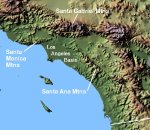
The Santa Ana Mountains are short peninsular mountain range along the coast of Southern California in the United States. They extend for approximately 35 mi (56 km) southeast of the Los Angeles Basin largely along the border between Orange and Riverside counties.
The range starts in the North at Santa Ana Canyon, through which the Santa Ana River flows. Its northernmost summit, at 3,045 ft, is Sierra Peak. From there, the major summits are Pleasants Peak (4,007 ft), Bedford Peak (3,800 ft) and Bald Peak (3,947 ft). The next two peaks, Modjeska (5,496 ft) and Santiago (5,687 ft; the higest summit in the range), form Saddleback Ridge. Saddleback, located approximately 20 mi (32 km) east of Santa Ana, is visible from most parts of Orange County, and is usually the only mountain in the range to be dusted with snow in winter storms.
South of Saddleback are Trabuco Peak (4,604 ft), Los Pinos Peak (4,520 ft), Elsinore Peak (3,575 ft), Sitton Peak (3,273 ft), and Margarita Peak (3,189). The range ends roughly at the Santa Margarita River.
Much of the range is within the Cleveland National Forest, although some parts are still owned by two century-old ranches: the Irvine Ranch and Rancho Mission Viejo.
External links
- The Nature Conservancy: Santa Ana Mountains (http://nature.org/wherewework/northamerica/states/california/preserves/art6334.html)
- State of California: California's Coastal Mountains (http://ceres.ca.gov/ceres/calweb/coastal/mountains.html)

