Phnom Penh
|
|
Phnom Penh (Khmer: Mul script Missing image
PhPenh1.png
Image:PhPenh1.png
; regular script Missing image
PhPenh.png
) is the capital and largest city of Cambodia.
| Contents |
Geography and climate
| City nickname: ""Penh"" | |
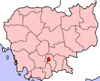
 Location of Phnom Penh | |
| Province | Phnom Penh |
| Governor | Kep Chuktema (Missing image Kep.png Image:Kep.png ) |
| Area –Land –Water | 290 km² km² km² |
| Population –Total (1998) –Density | (metropolitan area) 862,000 (city proper) 3446.6/km² |
| Time zone –Summer (DST) | (UTC) (UTC) |
| Latitude Longitude | |
| Official website: http://www.phnompenh.gov.kh | |
Geography
Phnom Penh, located in the south-west of Cambodia, at the Tonle Sap river, a tributary to the Mekong river. The city is located at 11°33' North, 104°55' East (11.55, 104.91667). [1] (http://earth-info.nga.mil/gns/html/cntry_files.html)
Climate
It's hot, with little seasonal variation.
Naming
The city takes its name from the Wat Phnom Daun Penh (known now as just the Wat Phnom or Hill Temple), built in 1373 to house five statues of Buddha on a man made hill 27 meters high. It was named after Daun Penh (Grandma Penh), a wealthy widow.
Phnom Penh was also previously known as Krong Chaktomuk (Chaturmukha) meaning "City of Four Faces". This name refers to the junction where the Mekong, Bassac, and Tonle Sap rivers cross to form an "X" where the capital is situated. Krong Chaktomuk is an abbreviation of its ceremonial name given by King Ponhea Yat which was "Krong Chaktomuk Mongkol Sakal Kampuchea Thipadei Sereythor Inthabot Borei Roth Reach Seima Maha Nokor" (Khmer: ក្រុងចតុមុខមង្គល សកលកម្ពុជាធិបតី សិរីធរបវរ ឥន្ធបត្តបុរី រដ្ឋរាជសីមា មហានគរ។).
History
Phnom Penh first became the capital of Cambodia after Ponhea Yat, king of the Khmer Empire fled Angkor Thom when it was captured by Siam in 1431. There are stupa behind Wat Phnom that house the remains of Ponhea Yat and the royal family as well as the remaining Buddhist statues from the Angkorean era.
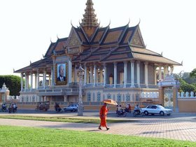
It was not until 1866 under the reign of King Norodom I that Phnom Penh became the permanent seat of government, and the Royal Palace (pictured) was built. This marked the beginning of the transformation of what was essentially a village into a great city with the French Colonialists expanding the canal system to control the wetlands, constructing roads and building a port.
By the 1920s Phnom Penh was known as the Pearl of Asia and over the next four decades continued to experience growth with the building of a railway to Kompong Som and the Pochentong International Airport.
During the Vietnam War, Cambodia, including Phnom Penh, was used as a base by the North Vietnamese Army and the NLF, and thousands of refugees from across the country flooded the city to escape the fighting between their own government troops, the NVA/NLF, the South Vietnamese and its allies and the Khmer Rouge. In 1975 the population was 2,000,000. The city fell to the Khmer Rouge and Democratic Kampuchea on April 17, the Cambodian New Year, and was evacuated by force; its residents being made to labor on rural farms as "new people". Tuol Svay Prey High School was taken over by Pol Pot's forces and was turned into the S-21 prison camp, where Cambodians were detained and tortured. It is now the Tuol Sleng Museum and along with Choeung Ek (The Killing Fields), 15 kilometers away, a memorial to those who were killed by the regime.
The Khmer Rouge were driven out of Phnom Penh by the Vietnamese in 1979 and people began to return to the city. A period of reconstruction began, spurred by continuing stability of government, attracting new foreign investment and aid by countries including France, Australia, and Japan. Loans were made from the Asia Development Bank and the World Bank to reinstate a clean water supply, roads and other infrastructure. By 1998, Phnom Penh's population was 862,000.
Administration
Administratively, although Phnom Penh is a municipality, its status is equal to provinces of Cambodian . It is subdivided into 7 districts and 76 communes.
- 1201 Chamkarmon
- 1202 Daun Penh
- 1203 Prampir Makara
- 1204 Toul Kork
- 1205 Dangkor
- 1206 Meanchey
- 1207 Russey Keo
See also
References
- Phnom Penh Government Website (http://www.phnompenh.gov.kh/) Accessed 18 April 2005
- History of Phnom Penh (http://www.phnompenh.gov.kh/english/history.html)
External links
- Phnom Penh Government Website in English (http://www.phnompenh.gov.kh/english/introduction.html)
- Phnom Penh Post (http://www.phnompenhpost.com/)
- Infoplease: Phnom Penh (http://www.infoplease.com/ce6/world/A0838827.html)
- The Phnom Penh Visitors Guide (http://www.canbypublications.com/phnompenh/ppintro.htm)
Template:Cambodiade:Phnom Penh es:Phnom Penh fr:Phnom Penh io:Phnom Penh he:פנום פן nl:Phnom Penh ja:プノンペン pl:Phnom Penh sk:Phnompenh fi:Phnom Penh sv:Phnom Penh zh:金边

