Peng Chau
|
|
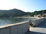
Peng_Chau_-_ferry_docks.jpg
Peng_Chau_-_looking_towards_Hong_Kong_from_Tung_Wan.jpg
Peng_Chau_-_on_top_of_Finger_Hill_looking_towards_Discovery_Bay.jpg
Peng Chau (坪洲 in pinyin: Píngzhōu; in Jyutping: ping4 zau1; literal meaning: "Flat Islet") is a small island located off the north-eastern coast of Lantau Island. Administratively, it is part of the Islands District of Hong Kong. Area: 0.98 km².
Peng Chau is known for its small island lifestyle, accessibility to fresh seafood, and many temples located around the island (including a Tin Hau temple built in 1792). The tallest point of the island is Finger Hill, which is 95m in height and provides hiking opportunities for those who seek them.
As of April 2003, the island is undergoing land degradation restorative work.
Transportation
The main mode of transportation on the island is bicycle; there are no motor cars apart from small construction and emergency vehicles.
Peng Chau is accessible by a ferry (New World First Ferry) from Central on Hong Kong Island, or by ferries from Mui Wo, Chi Ma Wan and Cheung Chau, or by Kai-to ferries from Discovery Bay on Lantau Island.
See also
External links
- commercial website containing information about Peng Chau (http://www.forestbar.com)
- Green Peng Chau Association (http://www.greenpengchau.org.hk)
- First Ferry hotspots information (http://www.nwff.com.hk/engtext/hotspots/brs203030.asp)
- Ryan Lau's Peng Chau page with photo gallery and temples and festivals information (http://www.ryanlau.com/index.php)

