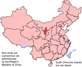
Ningxia
|
|
| Abbreviation: 宁 (pinyin: Níng) | |

| |
| Origin of Name | 宁 níng - tranquil 夏 xià - Western Xia "tranquil Xia" |
| Administration Type | Autonomous region |
| Capital and Largest City | Yinchuan |
| CPC Ningxia Committee Secretary | Chen Jianguo |
| Chairman | Ma Qizhi |
| Area | 66,000 km² (27th) |
| Population (2002) - Density | 5,720,000 (29th) 87/km² (25th) |
| GDP (2003) - per capita | 38.53 billion ¥ (30th) 6640 ¥ (24th) |
| Major Nationalities (2000) | Han - 79% Hui - 20% Manchu - 0.4% |
| Prefecture-level divisions | 5 |
| County-level divisions | 21 |
| Township-level divisions | 227 |
| ISO 3166-2 | CN-64 |
Ningxia (Template:Zh-stpw) is an autonomous region of the People's Republic of China, located on the northwest loess highland, the Yellow River flows through a vast area of its land.
| Contents |
History
Ningxia and its surrounding areas have been incorporated into the Qin empire as early as the 3rd century BC. Throughout the Han dynasty and the Tang dynasty, there were further evidence of settlements and by the 11th century, the Tangut tribe have established the Xixia dynasty on the outskirts of the then Song dynasty.
It then came under Mongol domination after Ghengis Khan conquered Yinchuan in the early 13th century. After the Mongols departed and its influences faded, Turkish speaking Muslims slowly began moving into Ningxia from the west. This created unavoidable tensions between the Han and the Hui ethnic groups in the following centuries.
In 1914, Ningxia was merged with the province of Gansu and became a part of it but then in 1928 Ningxia was created a province of China. In 1958, Ningxia formally became an autonomous region of China. In 1969, Ningxia's border was extended to the north and acquired parts of the Inner Mongolia autonomous region. However it was reverted back again in 1979.
Geography
Ningxia borders the Shaanxi and Gansu provinces, and the Inner Mongolia Autonomous Region.
- Rivers include: Yellow River
Ningxia is a relatively dry, desert region. There is a great deal of irrigation in order to support the growing of Wolfberries (a popular snack fruit throughout the region).
- Deserts include: Tengger desert in Shapotou
Demographics
Ningxia is the home of the Hui, one of the officially recognized Chinese minority groups. While ethnically indistinguishable from the Han (the major Chinese ethnic group) the Hui have been Muslims for many centuries. As a stop along the legendary Silk Road, the Hui were converted by the Islamic traders.
Home base of the fabled Hui culture.
Economy
Ningxia is the second poorest provinces/regions (Tibet being the last) of all of the PRC. Its GDP is just a little over 4.6 billion USD (2003) and an annual per capita of 6,640 RMB (ca. 801 USD) contributes to just 0.3% of the entire economy.
Tourism
One of Ningxia's main tourist spot is the famous Xixia Tomb located 30 kilometres west of Yinchuan. Located within an area of 50 square kilometres are the remnant tombs of 9 emperors of the Xixia dynasty and 200 other tombs from that era.
Miscellaneous topics
External links
- Ningxia regional government website (simplified Chinese) (http://www.nxny.gov.cn/)
| Province-level divisions administered by the People's Republic of China | Missing image PRC_flag_large.png Flag of the People's Republic of China | |||||||||||
| ||||||||||||
fr:Ningxia fi:Ningxia ja:寧夏回族自治区 nl:Ningxia zh:宁夏
Template:China-geo-stub
