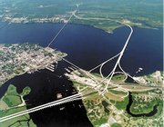
Neuse River
|
|
Typical of rivers in the Coastal Plain of North Carolina, the Neuse enters a basin of intermittent bottomland swamp on its journey towards its outlet. One interesting exception is the "Cliffs of the Neuse" area near Goldsboro, where the river cuts a narrow 30m (90ft) gorge through limestone and sandstone bluffs. The Neuse is prone to extremes in its flow carriage, often escaping its banks during wet periods, then reducing to a trickle that can be forded on foot during prolonged drought conditions.
The river's ties to human history are long, and many artifacts traced to ancient Native American settlement have been found along its muddy banks. In 1865, one of the first ironclad warships built by the Confederate Navy, the "Ram Neuse", was burnt and sunk to the river bottom by occupying Union Soldiers. It was discovered during historically low water, raised in 1963, and placed beside the river at the Governor Caswell Memorial in Kinston.
The Neuse flows through parts of 7 counties. Major cities and towns in close proximity to the Neuse are Durham, Neuse Township, Raleigh, Smithfield, Goldsboro, Kinston, and New Bern.
External links
- Neuse River Foundation (http://www.neuseriver.org/)
- NC State University (http://www.ncsu.edu/ncsu/CIL/WRRI/neuse.html)Template:US-south-geo-stub

