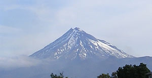
Mount Taranaki
|
|
| Taranaki | |
|---|---|
 Taranaki | |
| Elevation: | 2,518 m (8,261 ft) |
| Coordinates: | Template:Coor dms |
| Location: | New Zealand |
| Range: | none |
| Type: | Stratovolcano |
Mount Taranaki or Mount Egmont [1] (http://www.linz.govt.nz/rcs/linz/pub/web/root/core/Placenames/SearchPlaceNames/searchplacenames/index.jsp?p=63381) is a dormant stratovolcano located in the Taranaki region on the west coast of New Zealand's North Island.
The 2518-metre-high mountain is one of the most perfectly-shaped volcanic ash cones in the world. There is a secondary cone, Fantham's Peak, on the south side. Because of its resemblance to Mt. Fuji, Taranaki provided the backdrop for the Tom Cruise movie "The Last Samurai".
Mount Taranaki is geologically young, having commenced activity approximately 135,000 years ago. The most recent volcanic activity was a moderate ash eruption which occurred about 1755. Mount Taranaki is considered unusual in that it has experienced at least five of its major eruptions by the method of cone collapse. Few volcanoes have undergone more than one cone collapse. The vast volume of material involved in these collapses is reflected in the extensive ringplain surrounding the volcano. There is also evidence of lahars being a common result of eruption.
Taranaki is a relatively easy mountain to climb and many do so each summer. It takes a reasonably fit person a day to make the up-and-back climb. However, weather on the mountain can change rapidly, catching inexperienced trampers unawares. A number of people have died on the mountain after being caught unprepared in bad weather.
The mountain is revered by Maori who tell a legend about its origins.
| Contents |
The Mountain's Name
For many centuries the mountain was called Taranaki by the Maori. Captain Cook named it Mount Egmont after the Earl of Egmont. It appeared as Mt. Egmont on maps until the 1980s, when it was ruled that both names were equally valid for use. The Egmont name still applies to the national park which surrounds the peak. Incidentally, the name "Mount Taranaki" is linguistically redundant, since the word tara means "mountain peak". "Naki" is thought to come from ngaki, meaning "shining"—a reference to the winter, snow-clad, nature of the upper slopes. Geologists refer to it as "The Egmont Volcano"
Map_new_zealand_volcanoes.gif
National Park
In 1881, a circular area with a radius of six miles (9.6 km) from the summit was protected as a Forest Reserve. Areas encompassing the older volcanic remnants of Pouakai and Kaitake were later added to the reserve and in 1900 all this land was gazetted as Egmont National Park, the second national park in New Zealand. With intensively-farmed dairy pasture reaching right up to the mostly-circular park boundary, the change in vegetation is delineated remarkably in satellite images.
Recreation
The Stratford Mountain Club operates the Manganui skifield on the eastern slope. Equipment access to the skifield is by flying fox across the Manganui Gorge.
Access
There are three roads leading part-way up the mountain. The highest is to East Egmont plateau, with a viewing platform and parking facilities for the skifield. It lies at the transition between subalpine scrub and alpine herbfields.
There are park visitor centres at North Egmont and at Dawson Falls on the southeast side.
There is no road access on the western side. However, a road winds for 10 km though native bush over the saddle between Pouakai and Kaitake. Near the top of this road is the renowned Pukeiti Trust rhododendron garden.
NEO_egmont_big.jpg
Older volcanoes in the area
Taranaki sits upon the remains of three older volcanic complexes which lie to the northwest. Tectonic movement is slowly pushing the hot zone which feeds New Zealand's volcanoes southward. This trend is reflected in the newer secondary crater on the southeast side of Mt Taranaki, Fantham's Peak.
The oldest volcanic remnants consist of a series of lava plugs: Paritutu rock, which forms part of New Plymouth's harbour, and the Sugar Loaf Islands close offshore. These have been dated at 1.75 million years.
On the coast 15 km South of New Plymouth is the Kaitake range, last active approximately 500,000 years ago.
Nearest to Mt Taranaki is the Pouakai complex. Pouakai may have originated around the same time as Kaitake but remained active until about 240,000 years ago. Much of Pouakai's large ringplain was obliterated by the Egmont Volcano, the hills near Eltham being the only remnant to the south.
External links
- Mt Taranaki photos (http://www.virtualoceania.net/newzealand/photos/volcanic/taranaki/)
- Taranaki Volcano Cam (http://www.geonet.org.nz/taranaki.html)de:Taranaki
