Mount Edith Cavell
|
|
| Mount Edith Cavell | |
|---|---|
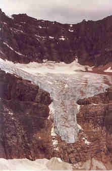
 Angel Glacier on North Face | |
| Elevation: | 3,363 metres (11,034 feet) |
| Coordinates: | Template:Coor dms |
| Location: | Alberta, Canada |
| Topo map: | NTS 83D/09 |
| Range: | Canadian Rockies |
| First ascent: | 1915 by A.J. Gilmour and E.W.D. Holway |
| Easiest route: | rock/ice climb |
Mount Edith Cavell is located in the Athabasca River and Astoria River valleys of Jasper National Park. The mountain was named in 1916 for Edith Cavell, an English nurse executed by the Germans during World War I.
A close up view of the north face of Mt. Edith Cavell is visible after a short hike to Cavell Meadows. The trailhead is by the parking lot at the end of Mt. Edith Cavell road. The trail to the meadows is 3.8 km one way, rising 370 metres (1,200 ft) to 2,135 metres (7,000 ft). The Canadian Rockies Trail Guide describes the trail in detail.
The hanging Angel Glacier is visible from Cavell Meadows, which spills over a 300 metre cliff on the north face.
Routes
- West Ridge (Normal Route) II
- East Ridge III 5.3
- North Face, East Summit IV 5.8
Reference
- Mt. Edith Cavell on PeakFinder (http://www.peakfinder.com/peakfinder.asp?PeakName=Mount+Edith+Cavell)
- Mount Edith Cavell on Bivouac (http://bivouac.com/MtnPg.asp?MtnId=8)
