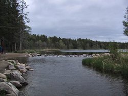
Lake Itasca
|
|
Wpdms_usgs_photo_itasca.jpg
Lake Itasca is a small glacial lake, approximately 1.8 square miles (4.7 square km) in area, in the Lake District of northwestern Minnesota in the United States. It is regarded as the source of the Mississippi River.
It is located in southwestern Clearwater County within Itasca State Park. It has an average depth of 20-35 feet (6-11 m).
The lake, at altitude 1,475 ft (450 m) above sea level, was determined by Henry Schoolcraft in 1832 to be the source of the Mississippi, which flows 2,340 mi (3,770 km) to the Gulf of Mexico. Schoolcraft had been part of a previous expedition in 1820 led by General Lewis Cass that had misidentified nearby Cass Lake as the source of the river. Schoolcraft coined the lake's name, which is a shortened version of the Latin phrase veritas caput, meaning "true head".
The channel of the Mississippi as it emerges from the lake was actually moved in the 1930s by the Civilian Conservation Corps, as part of project to create a more pleasant experience for visitors. The project included the draining of the surrounding swamp, the digging of a new channel, and the installation of a man-made rock rapids. Wading across the rapids in bare feet is a popular recreational activity for summer tourists.
The western arm of the lake is actually fed by two small streams on its south end. Nicolett Creek, which is considered too small to be considered as the headwaters, leads to a spring. Another small stream leads to Elk Lake, which is itself is fed by two additional streams. In 1887 Williard Glazier promoted a campaign to consider Elk Lake, which he called Glazier Lake, as the true source of the Mississippi. All of these streams are, however, generally considered too small to be categorized as the headwaters of the river.
See also
External link
- Lake Itasca (http://users.stlcc.edu/jangert/itasca/headwtr.html)

