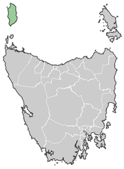
King Island, Australia
|
|
King Island is one of the islands that makes up the state of Tasmania, Australia. It is located in Bass Strait, off the north-western tip of Tasmania, about half way between Tasmania and Victoria. The island is named for Governor King of New South Wales, whose territory at the time include what is now Tasmania.
The population is about 2000, and the largest town is Currie, situated on the western side of the island. Grassy, on the east was a mining town, where sheelite was mined in an open cut mine. After the mine closed, Grassy virtually became a ghost town. It is notable for its cheese, mineral water, and also as a wind farm site for Hydro Tasmania.
Shipwrecks
Situated in the centre of Bass Strait, King Island has been the location of many ship wrecks, involving much loss of life, with the immigrant ship Cataraqui being the most disastrous.
Temperature and weather
- Average Annual Temperature: 10.1 - 16.5°C (50.2 - 61.7°F)
- Average January Temperature: 12.5 - 20.3°C (54.5 - 68.5°F)
- Average July Temperature: 7.8 - 12.9°C (46.0 - 55.2°F)
- Days over 30°C (86°F): 3.1
- Days over 35°C (95°F): 0.4
- Days under 2°C (35.6°F): 1.0
- Days under 0°C (32°F): 0.2
- Annual Rainfall: 901.3mm (35.48 inches)
- Average Annual Windspeed: 21.9 - 23.5 km/h (13.6 - 14.6 mp/h)
External links
- Municipality of King Island (http://www.kingisland.net.au)
- Hydro Tasmania's King Island Wind Farm (pdf file) (http://www.hydro.com.au/Documents/Renewables%20Development/5882Roaring40s.pdf)
- Currie climate averages (Australian Bureau of Meteorology) (http://www.bom.gov.au/climate/averages/tables/cw_098001.shtml)da:King Island

