
Image:Arles-location.png
|
|
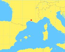
Map of western Mediterranean, showing location of Arles (France), 43.6667 N, 4.6333 E
Latitude and longitude as stated by islamicfinder.org (http://www.islamicfinder.org).
This image is an original work by Robert Dodier (User:Wile E. Heresiarch).
Template:Gfdl Template:Cc-by-sa-2.0
Map output by GMT (Generic Mapping Tools, http://gmt.soest.hawaii.edu), an open source cartographic software, using the map data that comes packaged with GMT. The map data were derived by the authors of GMT from two public domain databases. See Appendix K of The Generic Mapping Tools Version 3.4.4 Technical Reference and Cookbook (http://gmt.soest.hawaii.edu/doc/html/GMT_Docs/GMT_Docs.html).
Commands to create this map:
$ pscoast -Jm0.15i -R-5/15/36/48 -G255/240/100 -S100/200/255 -P -V -W1/255/255/120 -N1/1/150/150/150  -Dh -K > arles-location.ps
$ psxy -Jm0.15i -R-5/15/36/48 -Sc0.15  -G255/0/0 -V -P -O >> arles-location.ps
$ ps2epsi arles-location.ps
$ mogrify -format png arles-location.epsi
pscoast and psxy are from GMT. mogrify is from ImageMagick. ps2epsi is invoked solely to trim the bounding box down to just the size of the map image.bg:Картинка:Arles-location.png
File links
There are no pages that link to this file.