Huron River (Michigan)
|
|
The Huron River is the name of three different rivers in Michigan.
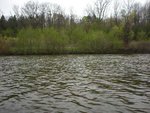
The Huron River is located in southeast portion of the U.S. state of Michigan and flows into Lake Erie. The Huron River is a typical Southeast Michigan stream; mud banks, slow stream flow and a low gradient define this river. It runs through, in order from its head to its mouth, Oakland, Livingston, Washtenaw, Wayne and Monroe Counties. There are 24 major tributaries totaling about 370 miles in addition to the mainstream . It is the only state-designated Country-Scenic Natural River in southeast Michigan. This includes 27.5 miles of the mainstream, plus an additional 10.5 miles of three tributaries.
The river was named after the Huron band of Native Americans who lived in the area. In Native languages, it was called cos-scut-e-nong sebee or Giwitatigweiasibi. It was part of a Native trade route.
Huron.JPG
The river has several dams forming lakes behind them. Some of these are Kent Lake, Barton Pond, Argo Pond, Ford Lake, Belleville Lake, and Flat Rock Pond.
The Huron River flows through numerous parks and is a prime canoeing river with a generally slow current and only few minor rapids or obstructions except for the Delhi rapids which is runnable by experienced canoeist and kayakers except during low water. The Huron passes through the cities of Ann Arbor, Ypsilanti, Belleville, Flat Rock and Rockwood.
The river is heavily fished by sportsmen for rock bass, sunfish, bluegill, black crappie, white bass, smallmouth bass, largemouth bass, northern pike, walleye, catfish, trout, muskie, and below Belleville Dam, Coho salmon, Chinook salmon, and Steelhead. suckers and carp are also common fish in the river.
The Big Huron River and the Little Huron River both flow mostly north near one another in the Upper Peninsula of Michigan. The east and west branches of the Big Huron arise in L'Anse Township in western Baraga County near the boundary with Marquette County. The east branch runs through a corner of Marquette County before flowing back into Baraga County. The east and west branches merge in Arvon Township shortly before flowing into Lake Superior in the northwest corner of Marquette county at the west end of the Huron Mountains and a few miles east of Huron Bay. The Little Huron River flows entirely within Powell Township in northwest Marquette County. It arises in the west end of the Huron Mountains an flows into Lake Superior about one mile east of the mouth of the Big Huron and about four miles south of the Huron National Wildlife Refuge. Somewhat confusingly, this is about four miles west of Huron River Point on Lake Superior.
External links
- Huron River website (http://huronriver.pinckneymich.net/index.html)
- Huron River Watershed Council (http://www.hrwc.org/)
- Huron River history (http://www.umich.edu/~bhl/bhl/huron/hurintro.html)

