Halawa, Hawaii
|
|
Hālawa is a stream, a valley, an ahupua‘a, a neighborhood, and a census-designated place (CDP) located in the ‘Ewa District, City & County of Honolulu, Hawai‘i. Hālawa Stream branches into two valleys: North and South Hālawa; North Hālawa is the larger stream and fluvial feature. Their confluence is within the H-3/H-201 highways exchange.
"Neighborhoods" of Hālawa are very disjointed, in part because of the significant highway exchanges (see below) that now occupy nearly all of the lower end of Hālawa Valley between Red Hill and Aloha Stadium. Much of the remainder of the valley along both sides of Interstate H-3 is developed into commercial and light industrial properties. On the east side of H-3 are found the State Animal Quarantine Station and the Halawa High and Medium Security Facility (main O‘ahu prison).
Where the valley widens out closer to Pearl Harbor occur residential neighborhoods: Foster Village adjacent to Āliamanu; and the stadium area between Aloha Stadium and Makalapa. The interfluve (uplands between valleys) on the west comprises Halawa Heights, extending up to Camp H. M. Smith. Along the lower, western edge, Halawa Heights merges with the neighhborhoods of ‘Aiea. As of the 2000 Census, the CDP had a total population of 13,891.
The U.S. Postal Code for Hālawa Heights is 96701 (the same as for ‘Aiea). The postal code for Foster Village, the stadium area, and Makalapa is 96818 (the same as Āliamanu).
Geography

Hālawa is located at 21°22'39" North, 157°55'22" West (21.377633, -157.922759)Template:GR. According to the United States Census Bureau, the neighborhood has a total area of 6.0 km² (2.3 mi²). 6.0 km² (2.3 mi²) of it is land and none of it is covered by water.
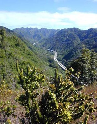
North Hālawa Valley is the route of Interstate H-3 from its western terminus with east-west Moanalua Freeway (H-201; connecting eastward to Honolulu or westward to H-1 and ‘Aiea) to the 1100-foot (335-m) elevation entrance into the Tetsuo Harano Tunnels penetrating the Ko‘olau crest. The freeway continues beyond to Kāne‘ohe on windward O‘ahu.
Most of Hālawa Valley is undeveloped, and there are numerous archaeological sites in this valley. These sites are one reason that a significant proportion of Interstate H-3 within the valley is carried on a viaduct (see photo at right). Although very expensive to construct, the viaduct offers significant returns in terms of preservation of both archeological sites and stream ecology.
Demographics
As of the census of 2000, there were 13,891 people, 4,142 households, and 3,276 families residing in the CDP. The population density was 2,301.9/km² (5,974.5/mi²). There were 4,289 housing units at an average density of 710.7/km² (1,844.7/mi²). The racial makeup of the town was 15.50% White, 1.83% African American, 0.20% Native American, 50.90% Asian, 10.43% Pacific Islander, 0.84% from other races, and 20.31% from two or more races. 6.52% of the population were Hispanic or Latino of any race.
There were 4,142 households out of which 30.3% had children under the age of 18 living with them, 60.1% were married couples living together, 13.9% had a female householder with no husband present, and 20.9% were non-families. 15.5% of all households were made up of individuals and 5.2% had someone living alone who was 65 years of age or older. The average household size was 3.28 and the average family size was 3.64.
In the CDP the population was spread out with 23.4% under the age of 18, 9.9% from 18 to 24, 28.3% from 25 to 44, 22.6% from 45 to 64, and 15.8% who were 65 years of age or older. The median age was 37 years. For every 100 females there were 98.8 males. For every 100 females age 18 and over, there were 98.3 males.
The median income for a household in Hālawa in 2000 was $63,176, and the median income for a family was $68,519. Males had a median income of $35,764 versus $28,527 for females. The per capita income for the census tract then was $21,868. 10.1% of the population and 7.5% of families were below the poverty line. Out of the total population, 20.9% of those under the age of 18 and 3.7% of those 65 and older were living below the poverty line.
