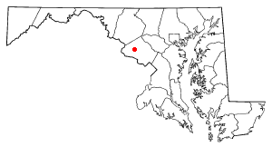
Germantown, Montgomery County, Maryland
|
|
Germantown is an unincorporated, but urbanized Census-Designated Place located in Montgomery County, Maryland. It is the second most populous Census-Designated Place in Maryland and, if incorporated, would become the second most populous city in Maryland.
History
In the 1830s and 1840s, a large number of German business owners, some of whom were immigrants from Germany and others relocating from Pennsylvania, settled at the crossroads where roads now known as Maryland Route 118 and Clopper Road. While most of the local landowners and farmers were English, travelers remembering the accents of the shop-owners called the area Germantown, and the name stuck.
This place has been designated a Census-Designated Place by the United States Census Bureau and it is the only Germantown, Maryland recognized by the United States Postal Service. It has the assigned ZIP Codes of 20874 and 20876 for delivery and 20875 for post office boxes only.
Geography
Germantown is located at Template:Coor dm.
According to the United States Census Bureau, the community has a total area of 28.0 km² (10.8 mi²). 27.9 km² (10.8 mi²) of it is land and 0.1 km² (0.1 mi²) of it is water. The total area is 0.46% water.
Demographics
As of the census of 2000, there are 55,419 people, 20,893 households, and 14,123 families residing in the area. The population density is 1,986.8/km² (5,144.0/mi²). There are 21,568 housing units at an average density of 773.2/km² (2,001.9/mi²). The racial makeup of the area is 62.20% White, 19.13% African American, 0.34% Native American, 9.84% Asian, 0.07% Pacific Islander, 4.22% from other races, and 4.20% from two or more races. 10.21% of the population are Hispanic or Latino of any race.
There are 20,893 households out of which 41.2% have children under the age of 18 living with them, 49.8% are married couples living together, 13.7% have a female householder with no husband present, and 32.4% are non-families. 23.5% of all households are made up of individuals and 1.8% have someone living alone who is 65 years of age or older. The average household size is 2.65 and the average family size is 3.19.
In the area, the population is spread out with 28.9% under the age of 18, 7.7% from 18 to 24, 43.0% from 25 to 44, 17.3% from 45 to 64, and 3.1% who are 65 years of age or older. The median age is 31 years. For every 100 females there are 94.9 males. For every 100 females age 18 and over, there are 90.6 males.
The median income for a household in the area is $62,431, and the median income for a family is $67,204. Males have a median income of $46,039 versus $37,237 for females. The per capita income for the area is $26,709. 4.6% of the population and 3.5% of families are below the poverty line. Out of the total people living in poverty, 5.9% are under the age of 18 and 9.9% are 65 or older.

