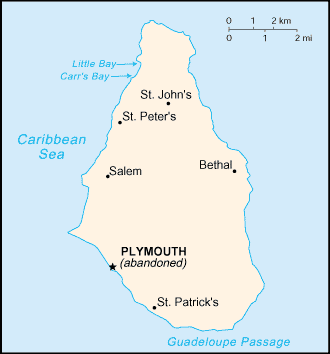
Geography of Montserrat
|
|
Location: Caribbean, island in the Caribbean Sea, southeast of Puerto Rico
Geographic coordinates: Template:Coor dm
Map references: Central America and the Caribbean
Area:
total:
100 sq km
land:
100 sq km
water:
0 sq km
Land boundaries: 0 km
Coastline: 40 km
Maritime claims:
exclusive fishing zone:
200 nm
territorial sea:
3 nm
Climate: tropical; little daily or seasonal temperature variation
Terrain: volcanic islands, mostly mountainous, with small coastal lowland
Elevation extremes:
lowest point:
Caribbean Sea 0 m
highest point:
Chances Peak (in the Soufriere Hills) 914 m
Natural resources: NEGL
Land use:
arable land:
20%
permanent crops:
0%
permanent pastures:
10%
forests and woodland:
40%
other:
30% (1993 est.)
Irrigated land: NA sq km
Natural hazards: severe hurricanes (June to November); volcanic eruptions (full-scale eruptions of the Soufriere Hills volcano occurred during 1996-97)
Environment - current issues: land erosion occurs on slopes that have been cleared for cultivation
- See also : Montserrat
Source
- CIA World Factbook (http://www.cia.gov/cia/publications/factbook/print/mh.html)

