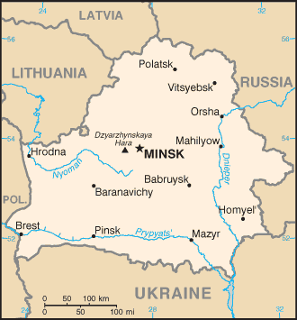
Geography of Belarus
|
|
This article describes the geography of Belarus.
- Location
- Eastern Europe, east of Poland
- Geographic coordinates
- Template:Coor d
- Map references
- Commonwealth of Independent States
- Area
-
- Total: 207,600 km²
- Land: 207,600 km²
- Water:
- Area comparative
-
- Australia comparative: slightly smaller than Victoria
- Canada comparative: half the size of Newfoundland and Labrador
- Europe comparative: 13th place, slightly smaller than the United Kingdom and Romania
- United States comparative: slightly smaller than Kansas
- Land boundaries
- Coastline
- 0 km (landlocked)
- Maritime claims
- None (landlocked)
- Climate
- Transitional between continental and maritime; cold winters (average January temperatures are in the range −8 °C to −2 °C), cool and moist summers (average temperature 15 °C to 20 °C).
- Terrain
- Generally flat, containing much marshland
- Elevation extremes
-
- Lowest point: Nyoman River 90 m
- Highest point: Dzyarzhynskaya Hara 345 m
- Natural resources
- Forests, peat deposits, small quantities of oil and natural gas, granite, dolomitic limestone, marl, chalk, sand, gravel, clay
- Land use
-
- Arable land: 29%
- Permanent crops: 1%
- Permanent pastures: 15%
- Forests and woodland: 34%
- Other: 21% (1993 est.)
- Irrigated land
- 1,150 km² (1998 est.)
- Water resources
- About 20,000 rivers and streams, with the total length of 91,000 km, and about 11,000 lakes, including 470 lakes with the area exceeding 0.5 km² each. Naroch is the largest lake (79.2 km², the deepest point about 25 m). Significant amounts of swampy area, notably in the Polesie region.
- Natural hazards
- NA
- Environment - current issues
-
- Soil pollution from pesticide use.
- South-Eastern part of the country contaminated with fallout from 1986 nuclear reactor accident at Chornobyl, Ukraine, receiving about 60% of total fallout. Vast amounts of territory in Homyel and Mahilyow voblasts rendered uninhabitable. Roughly 7,000 km² (2,700 mi²) of soil were contaminated by caesium-137 to levels greater than 15 curies (550 gigabecquerels) per square kilometer, i.e., taken from human usage for indefinite time. In 1996 the areas contaminated with over 1 Ci/km² (37 GBq/km²) of caesium-137 constituted about 21% of the total territory (only 1% decrease compared to 1986), and in 2002 over 1.5 mln people still lived in this area.
- Environment - international agreements
-
- Party to treaties: Air Pollution, Air Pollution-Nitrogen Oxides, Air Pollution-Sulphur 85, Biodiversity, Climate Change, Endangered Species, Environmental Modification, Hazardous Wastes, Marine Dumping, Nuclear Test Ban, Ozone Layer Protection, Ship Pollution, Wetlands
- Signed, but not ratified: Law of the Sea
- Geography - note
- Landlocked
Reference
Much of the material in this article is adapted from the CIA World Factbook 2000 and 2003.
External links
- Chernobyl data for Belarus (http://www.chernobyl.info/files/doc/TabE_Minsk.pdf)

