Geography of American Samoa
|
|
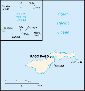
This article describes the geography of American Samoa.
Missing image
American_Samoa.png
American_Samoa.png
Tutuila Island - NASA NLT Landsat 7 (Visible Color) Satellite Image
- Location
- Oceania, group of islands in the South Pacific Ocean, about two thirds of the way from Hawaii to New Zealand
- Geographic coordinates
- Template:Coor dm
- Map references
- Oceania
- Area
-
- Total: 199 km²
- Land: 199 km²
- Water: 0 km²
- Note: Includes Rose Island and Swains Island
- Area - comparative
- Slightly larger than Washington, DC
- Land boundaries
- 0 km
- Coastline
- 116 km
- Maritime claims
-
- Exclusive economic zone: 200 nm (370.4 km)
- Territorial sea: 12 nm (22.2 km)
- Climate
- Tropical marine, moderated by southeast trade winds; annual rainfall averages about 3 m; rainy season from November to April, dry season from May to October; little seasonal temperature variation
- Island Names in order of size
- Tutuila, Ta'u, Ofu, Olosega, Aunu'u, Swain's, Rose
- Terrain
- Five volcanic islands with rugged peaks and limited coastal plains, two coral atolls (Rose Island, Swains Island)
- Elevation extremes
-
- Lowest point: Pacific Ocean 0 m
- Highest point: Lata 966 m
- Natural resources
- Pumice, pumicite
- Land use
-
- Arable land: 5%
- Permanent crops: 10%
- Permanent pastures: 0%
- Forests and woodland: 70%
- Other: 15% (1993 est.)
- Irrigated land
- NA km²
- Natural hazards
- Hurricane season from December to March; Hurricane Heta struck Tutuila and Manu`a January, 2004.
- Landslides
- Environment - current issues
- Limited natural fresh water resources; the water division of the government has spent substantial funds in the past few years to expand well system, improve water catchments and pipelines
- Geography - note
- Pago Pago has one of the best natural deepwater harbors in the South Pacific Ocean, sheltered by shape from rough seas and protected by peripheral mountains from high winds; strategic location in the South Pacific Ocean
MapQuest zoom level 4 shows the location with respect to the state of Samoa.he:גאוגרפיה של סמואה האמריקאית

