|
|
| Statistics | |
|---|---|
| State: | North Rhine-Westphalia |
| Capital: | Gütersloh |
| Adm. Region: | Detmold |
| Area: | 967.18 km² |
| Inhabitants: | 345,370 (2001) |
| pop. density: | 357 inh./km² |
| Car identification: | GT |
| Homepage: | http://www.kreis-guetersloh.de |
| Map | |
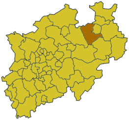
Gütersloh is a Kreis (district) in the north-east of North Rhine-Westphalia, Germany. Neighboring districts are Osnabrück, Herford, district-free Bielefeld, Lippe, Paderborn, Soest and Warendorf.
| Contents |
History
It was created in 1973 in the reorganization of the districts in North Rhine-Westphalia, when the previous districts of Halle and Rheda-Wiedenbrück were merged. Also the districts Bielefeld, Paderborn, Beckum und Warendorf had to cease parts of their area to the newly formed district. The precursor districts were created in 1816 when the new Prussian province of Westphalia was established.
Geography
The east of the district is covered by the Teutoburg Forest, which also contains the highest elevation of the district, the Hengeberg (316m). In the west there is the source of the Ems river. The Ems valley also contains the lowest point of the district, near Harsewinkel with 56m.
Coat of arms

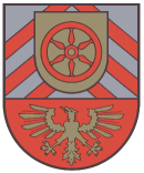
| The coat of arms was adopted with the creation of the district in 1973 by combining the symbols from the arms of the previous districts Halle and Rheda-Wiedenbrück. The three elements derive from the medieval counties in the area now covered by the district.
The golden eagle in the bottom of the coat comes from the duchy of Rietberg. The wheel in the middle derives from the sign of the city Osnabrück, which owned the Amt Reckenberg. The chevrons in the top part are the symbol of the duchy of Ravensberg. |
Towns and municipalities
| Towns | Municipalities |
|---|---|
|
External links
- Official website (http://www.kreis-guetersloh.de) (German)
Template:Germany districts north rhine-westphaliade:Kreis Gütersloh fr:Gütersloh (arrondissement) nl:Gütersloh (district)

