County Fermanagh
|
|
| County Fermanagh | |
|---|---|

| |
| Area: | 1,691 kmē |
| Population: | 55,000 (estimate) |
| Province: | Ulster |
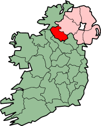
County Fermanagh (Contae Fear Manach in Irish) is the westernmost of the Six Counties that form Northern Ireland. It belongs to the province of Ulster. Fermanagh is often referred to as Ireland's Lake District. The county is approximately 120 km from Belfast and 160 km from Dublin.
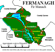
The county borders County Tyrone (Northern Ireland) to the north-east, County Monaghan (Republic of Ireland) to the south-east, County Cavan (ROI) and County Leitrim (ROI) to the south-west and County Donegal (ROI) to the north-west. Fermanagh is the only county of Northern Ireland not to border onto Lough Neagh.
| Contents |
Government
Fermanagh is also the name of one of the 26 district councils in Northern Ireland which contains all of the county it is named after, plus a small section of County Tyrone in the Dromore and Kilskeery road areas. Fermanagh is part of the Fermanagh and South Tyrone Parliamentary Constituency renowned for high levels of voting and for electing IRA hunger-striker Bobby Sands as a Member of Parliament in a by-election for the area for a short time before his death in 1981.
Geography
County Fermanagh is a predominantly rural region with its geography dominated by two lakes: Upper Lough Erne and Lower Lough Erne. These 70 km worth of lakes are known collectively as Lough Erne, are now linked to the River Shannon and its waterways, via the Shannon-Erne Waterway Canal, making the entire system the longest navigable inland waterway in Europe. Smaller lakes in the county include Lough Scolborn. In addition, Fermanagh shares many lakes: Lough Melvin (with the Republic of Ireland), Lough Macnean Upper and Lough Macnean Lower (both lying on the Cavan border).
The peak of Cuilcagh, part of the Cuilcagh Mountains range, on the Fermanagh/Cavan border is the highest point in Fermanagh (665 metres, 2182 feet). Other mountains/ranges include Tappghan Mountain (on the border with Tyrone), Brougher Mountain (on the border with Tyrone), Molly Mountain, Slieve Rushen (on the border with Cavan), Derrin Mountain and Slieve Beagh on the Tyrone border). Much of the western and eastern areas of the county are forested.
Industry and Tourism
Agriculture and tourism are some of the most important industries in Fermanagh. The main types of farming in the area are beef, dairy, sheep, pigs and some poultry. Most of the agricultural land is used as grassland for grazing and silage or hay rather than other crops. The waterways are extensively used by cabin cruisers, other small pleasure craft and anglers alike. The main town of Fermanagh is Enniskillen (Inis Ceithleann, Ceithleann's island). The island town hosts a range of attractions including the Castle Coole Estate and Enniskillen castle which is home to the museum of The Royal Inniskilling Fusiliers and the 5th Royal Inniskilling Dragoon Guards.
Attractions outside of Enniskillen include:
- The Belleek Pottery
- Crom Estate
- Devenish Island
- Florence Court
- Loughnavar Forest Park
- The Marble Arch Caves
See the list of places in County Fermanagh for all villages and towns.
Books
Fermanagh : its special landscapes : :a study of the Fermanagh countryside and its heritage /Department of the Environment for Northern Ireland. - Belfast : HMSO, 1991
Friel, Charles P.. - Fermanagh's railways : a photographic tribute / Charles P. Friel, Norman Joh. - Newtownards, Co. Down : Colourpoint Press, 1998.
Livingstone, Peadar. - The Fermanagh story :a documented history of the County Fermanagh from the earliest times to the present day - Enniskillen : Cumann Seanchais Chlochair, 1969.
Lowe, Henry N. - County Fermanagh 100 years ago : a guide and directory 1880. - Belfast : Friar's Bush Press, 1990.
Related links
- Enniskillen.Com (http://www.enniskillen.com)
Template:Ireland countiesde:Fermanagh (County) es:Condado de Fermanagh ga:Contae Fhear Manach nl:County Fermanagh no:Fermanagh (grevskap)

