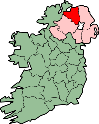
County Londonderry
|
|
- For other places with similar names, see Londonderry (disambiguation) and Derry (disambiguation).
| County Londonderry | |
|---|---|

| |
| Area: | 2,074 kmē |
| Population: | 213,000 (estimate) |
| Province: | Ulster |
County Londonderry or County Derry (Doire in Irish) is one of the six counties of Northern Ireland. It was named for its main town (later city and administrative centre), Derry (later Londonderry), and the Plantation of Ulster by London livery companies.
As with the town, its name is subject to a dispute, with the form Derry preferred by nationalists and unionists preferring Londonderry. The name Derry is officially used in the Republic, while the British authorities use the name Londonderry.
Unlike the town, historically there was not a preceding County Derry: it was established by combining the former County of Coleraine with small parts of Counties Antrim, Donegal, and Tyrone at the behest of the London companies so that they could control both banks of the mouths of the rivers Foyle and Bann and have access to sufficient wood for construction.
Since 1973, administration has been divided between district councils. The districts covering the county are Derry City; the districts of Coleraine, Limavady, and Magherafelt; and part of the district of Cookstown, which is largely in County Tyrone.
For more information about the City/County Name:
http://news.bbc.co.uk/1/hi/northern_ireland/2501183.stm

Www.wesleyjohnston.com-users-ireland-maps-counties-londonderry.gif
See the list of places in County Londonderry for all villages, towns and cities.
Template:Ireland countiesde:Londonderry (County) es:Condado de Londonderry ga:Contae Dhoire nl:County Londonderry no:Londonderry (grevskap)
