Coos Bay, Oregon
|
|
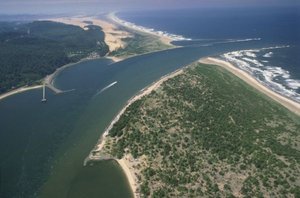
Coos Bay is a city located in Coos County, Oregon. As of the 2000 census, the city had a total population of 15,374. The city is located at the mouth of the Coos River on Coos Bay on the Pacific Ocean.
| Contents |
Geography
Coos Bay is located at 43°22'35" North, 124°14'14" West (43.376456, -124.237102)Template:GR.
According to the United States Census Bureau, the city has a total area of 41.3 km² (15.9 mi²). 27.4 km² (10.6 mi²) of it is land and 13.8 km² (5.3 mi²) of it is water. The total area is 33.52% water.
Demographics (2000 census)
There are 15,374 people residing in the city, comprising 6,497 households and 4,028 families. The population density is 560.5/km² (1,451.9/mi²). There are 7,094 housing units at an average density of 258.6/km² (669.9/mi²). The racial makeup of the city is 90.75% White, 0.37% African American, 2.27% Native American, 1.44% Asian, 0.31% Pacific Islander, 1.35% from other races, and 3.51% from two or more races. 4.49% of the population are Hispanic or Latino of any race.
There are 6,497 households out of which 27.1% have children under the age of 18 living with them, 46.3% are married couples living together, 11.6% have a female householder with no husband present, and 38.0% are non-families. 30.7% of all households are made up of individuals and 12.9% have someone living alone who is 65 years of age or older. The average household size is 2.29 and the average family size is 2.83.
In the city the population is spread out with 22.6% under the age of 18, 9.2% from 18 to 24, 25.2% from 25 to 44, 23.8% from 45 to 64, and 19.2% who are 65 years of age or older. The median age is 40 years. For every 100 females there are 94.4 males. For every 100 females age 18 and over, there are 90.8 males.
The median income for a household in the city is $31,212, and the median income for a family is $38,721. Males have a median income of $32,324 versus $22,192 for females. The per capita income for the city is $18,158. 16.5% of the population and 12.7% of families are below the poverty line. Out of the total population, 21.0% of those under the age of 18 and 9.9% of those 65 and older are living below the poverty line.
Chronology of events
- 1579 Francis Drake is said to have sought shelter in the bay for the Golden Hinde and its crew.
- 1853 City founded and named Marshfield after the Massachusetts hometown of one of the founders.
- 1866 Cape Arago Lighthouse begins operation.
- 1871 Marshfield post office established.
- 1872 Coos Bay Wagon Road opens, connecting Coos County with Douglas County's Umpqua River valley, across the Coast Range of mountains.
- 1874 Marshfield incorporated.
- 1908 The first automobile arrives in Marshfield via the Coos Bay Wagon Road. (Previous autos arrived by ship at the Port of Coos Bay, or by way of lesser trails.)
- 1944 Residents vote to name the city Coos Bay.
- 1922 A fire ends up burning down a large portion of the business district.
- 1925 The Egyptian Theatre opens (and is still open as of 2003).
- 1928 KOOS radio begins broadcasting.
- 1942 Nearby Mt. Emily becomes the first US mainland site to be bombed by the Japanese in World War II.
- 1951 Steve Prefontaine is born.
- 1962 The most powerful non-tropical storm in US mainland history, the Columbus Day Storm, hits.
- 1972 The Oregon Dunes National Recreation Area is established.
- 1999 The M/V New Carissa freighter runs aground.
External links
- The city's official website (http://www.coosbay.org/)

