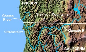
Chetco River
|
|
The Chetco River is a river in southwestern Oregon in the United States, approximately 55 mi (88 km) long. It drains a rugged isolated coastal region in the extreme southwestern corner of the state near the California border, descending steeply from 3700 ft (1130 m) to the Pacific Ocean over its course. Except for the lower 5 mi (8 km), the river is located in the Siskyou National Forest.
It rises in southern Curry County in the Kamiopsis Wilderness Area northwest of Chetco Peak in the Coastal Range. It flows northwest, passing west of Pearsol Peak, then southwest, passing between Mount Emily (south) and Bosley Butte (north). It empties into the Pacific Ocean at Brookings, approximately 5 mi (8 km) north of the California state line.
In 1988 the United States Congress designated the upper 45 mi (72 km) of the river, from its headwaters to the boundary of Siskyou National Forest, as the Chetco Wild and Scenic River, as part of the National Wild and Scenic River program.
In winter, salmon and steelhead fishing, as well as whitewater kayaking are the primary recreational uses. In summer, fishing, four-wheel driving, swimming, boating, camping, sightseeing and picnicking are the major attractions. Alfred A. Loeb State Park is located along the river 4 mi (6 km) northwest of its mouth.
See also
External link
- Chetco Wild and Scenic River (http://www.nps.gov/rivers/wsr-chetco.html)

