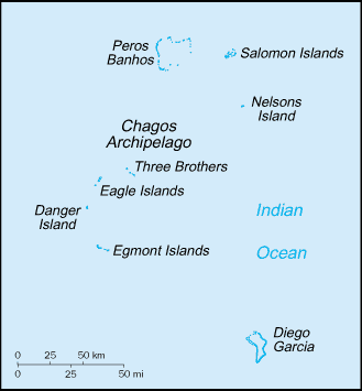
Chagos Archipelago
|
|
| Missing image Merge_articles.png | It has been proposed that this article or section be merged with All Atolls of Chagos Archipelago.
This request may be discussed on the article's talk page. |
| Contents |
Geography
The Chagos Archipelago is a group of six atolls with more than 60 individual tropical islands in the Indian Ocean, that lies about 500 km (300 miles) due south of the Maldives in the Indian Ocean, and 1600 km (1000 miles) southwest of India, halfway between Africa and Indonesia. Comprising the British Indian Ocean Territory, the entire archipelago is a British overseas territory.
The entire land area of the islands is a mere 60 km2, with the largest island, Diego García, having an area of 27.20 km2. The archipelago consists of seven atoll formations of all sizes which have islands oder cays permanently over water, including the largest atoll structure of the world, the Great Chagos bank with a total area (mostly water) of 13,000 km2.
- Diego García (including Diego Garcia and three smaller islets at the Northern end)
- Egmont Islands or Six Iles (7 islets)
- Peros Banhos (27 islets)
- Salomon Islands (11 islets)
- Great Chagos Bank (7 islets)
- Blenheim Reef (3 islets)
- Speakers Bank (1 islet)
The largest individual islands by are are Diego García (27.20 km2), Eagle (Great Chagos Bank, 2.45 km2), Ile Pierre (Peros Banhos, 1.50 km2), Eastern Egmont (Egmont Islands, 1.50 km2), Ile de Coin (Peros Banhos, 1.28 km2) and Ile Boddam (Salomon Islands, 1.08 km2).
The number of atolls in the Chagos Islands is given as four or five in most sources, plus two island groups and two single islands, mainly because it is not recognized that the Great Chagos Bank is a huge atoll structure (including those two island groups and two single islands), and because it is not recognized that Blenheim Reef and Speakers Bank have islets or cays above or just reaching the high water mark.
In addition to the seven atolls with dry land reaching at least the high water mark, there are at least nine banks, most of which can be considered permanently submerged atoll structures.
- Colvocoresses Reef
- Benares Shoals
- Victory Bank
- Cauvin Bank
- Pitt Bank
- Ganges Bank
- Wight Bank
- Centurion Bank
- Owen Bank
Resources
The main natural resources of the area are sugarcane, coconuts, and fish.
Climate
Tropical marine; hot, humid, moderated by trade winds. Climate is characterised by plenty of sunshine, warm temperatures, showers and light breezes. December through February is considered the rainy season (summer monsoon); typical weather conditions include light west-northwesterly winds and warmer temperatures with more rainfall. June through September is considered the drier season (winter), characterised by moderate south-easterly winds, slightly cooler temperatures and less rainfall. The annual mean rainfall is 2600mm (100 inches), varying from 105mm (4 inches) during August to 350mm (14 inches) during January.
History
The islands were discovered by Vasco da Gama in the early sixteenth century, then claimed in the eighteenth century by France as a possession of Mauritius. The United Kingdom gained possession of both Mauritius and the archipelago in 1814, and retained the islands as part of the British Indian Ocean Territory when Mauritius gained independence. Since 1976, the archipelago has been coterminous with the British Indian Ocean Territory, but it is also claimed by Mauritius but NOT the Seychelles, despite popular belief.
Although there was no pre-European population, a few hundred people of mostly Indian descent known as the Ilois lived on the islands for several hundred years until they were expelled to Mauritius by the British Government between 1967 and 1973.
Currently, the only habitation is a joint US-UK naval support facility on Diego Garcia. Other uninhabited islands, especially in the Salomon group, are common stopping points for long-distance sailors travelling from Southeast Asia to the Red Sea or the coast of Africa.
The British Government instituted an investigation into relocating the former islanders to some of the formerly inhabited islands, but concluded that this was impossible due to a lack of fresh water and risk of flooding. This is disputed by the former islanders, who point out that rainfall in the archipelago is among the highest in the world and that the 2004 Indian Ocean earthquake was reported as causing little damage in the islands.
Recent High Court rulings have opened the door for these displaced people to return to their land. Although this ruling makes it legal for these people to return, there has been no timetable set for their return, and no concrete plans have been laid out.
See also
External links
- Chagos Conservation Management Plan (PDF) (http://www.chagosconservationtrust.org/Conservation%20Plan/Chagos%20Conservation%20Management%20Plan%202003.pdf)
- Coral Reef Degradation in the Indian Ocean (http://www.cordio.org/reports/CORDIO_Status_Report_1999.pdf)de:Tschagos-Archipel

