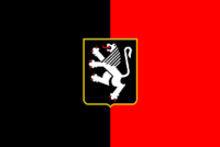
Aosta Valley
|
|

| |
| Capital | Aosta-Aoste |
| President | Carlo Perrin (Union Valdôtaine) |
| Provinces | none |
| Municipalities | 74 |
| Area | 3,263 km² |
| - Ranked | 20th (1.1 %) |
| Population (2001) - Total - Ranked | 119,548 20th (0.2 %) 37/km² |

| |
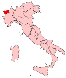
| Map higlighting the location of Valle d'Aosta Val d'Aoste in Italy | |
Aosta Valley (in French Vallée d'Aoste, in Italian Valle d'Aosta) is a mountainous region in north-western Italy, the smallest of Italy's regions. It is bordered by France to the west, Switzerland to the north and the region of Piedmont to the south. The region has a special autonomous status and forms one of the Provinces of Italy. The regional capital is Aosta-Aoste.
The region covers 3,263 km² and has a population of about 113,000, concentrated in the valley bottomlands and partially Francophone. French is used in the government acts and laws, though the language actually spoken by the biggest part of the population is Francoprovençal, a patois that used to be spoken more generally in Savoy, French-speaking Switzerland, Lyon area and the Jura. The valle d'Aosta is the region in which the language is most in use.
The Valle d'Aosta is an Alpine valley that with its side valleys includes the Italian slopes of Mont Blanc and the Matterhorn; its highest peak is the Gran Paradiso, protected in Gran Paradiso National Park, established in 1922. It is a major centre for winter sports, most famously at Courmayeur. The Dora Baltea has its origins in the Valle d'Aosta, flowing south to join the Po.
The upper Val d'Aosta is the traditional southern starting-point for the tracks, then roads, which divided here to lead over the Alpine passes. The road through the Great St Bernard Pass (or today the Great St Bernard Tunnel) leads to Martigny, Valais, and the one through the Little St Bernard Pass to Bourg-Saint-Maurice, Savoie. Today Aosta is joined to Chamonix in France by the Mont Blanc Tunnel, a road tunnel on E25 running underneath the Alps.
The area was of strategic importance, under the control of many different rulers after the collapse of Roman rule in the 5th century, until it passed to the house of Savoy in the 11th century. Valle d'Aosta was established as an autonomous region of Italy in 1948.
History
The first inhabitants of the Valle d'Aosta were Celts and Ligures, whose language lingers in some local placenames. Rome conquered the region from the local Salassi ca. 25 BC and founded Augusta Praetoria (Aosta) to secure the strategic mountain passes, which they improved with bridges and roads. After Rome it preserved traditions of autonomy, reinforced by its seasonal isolation, though it was loosely held in turns by the Goths and the Lombards, then by the Burgundian kings in the 5th century, followed by the Franks, who overrran the Burgundian kingdom in 534. At the division among the heirs of Charlemagne in 870, the Valle d'Aosta formed part of the Lotharingian Kingdom of Italy, in a second partition a decade later, part of the Kingom of Upper Burgundy, which was joined to the Kingdom of Arles— all doubtless without many significant corresponding changes in the personnel of the virtually independent fiefs in the Valle d'Aosta. In 1031/2 Umberto Biancamano, the founder of the house of Savoy, received the title count of Aosta from the Emperor Conrad II of the Franconian line and built himself a commanding fortification at Bard. St Anselm of Canterbury was born in Aosta in 1033/4. The region was divided among strongly fortified castles, and in 1191 Tomaso di Savoia found it necessary to grant to the communes a Carta delle Franchigie ("Charter of Liberties") that preserved autonymy, rights that were fiercely defended until 1770, when they were revoked, to tie Aosta more closely to the Piedmont, but which kept re-surfacing during post-Napoleonic times. Under Mussolini, a forced programme of "Italianization", including population transfers of Valdostans into Piedmont and Italian-speaking workers into Aosta, fostered movements towards separatism; Aosta was regranted its autonymy in 1948 [1] (http://www.esteri.it/eng/7_45_109_178.asp). In the mid-13th century Emperor Frederick II made the County of Aosta a duchy, and its arms were carried in the Savoia arms until the reunification of Italy, 1870 [2] (http://www.heraldica.org/topics/national/italy1.htm). The region remained part of Savoy lands, with the exception of a French occupation, 1539 – 1563.
During the Middle Ages the region remained strongly feudal, and castles, such as those of the Challant family in the Valley of Gressoney, still dot the landscape. In the 12th and 13th centuries, German-speaking Walser communities were established in the Gressoney, and some communes retain their separate Walser identity even today.
The Valle d'Aosta remained agricultural and pastoral until the construction of dams to harness the potential of its hydroelectric power brought metal-working industry to the region.
- "Particularism" (http://www.aostavalley.com/PV/ppeng.htm): autonomy in the Valle d'Aosta
List of municipalities
External links
- Aosta Valley (http://www.aostavalley.com/primaeng.html)
- Regione Autonoma Valle d'Aosta / Région Autonome Vallée d'Aoste (http://www.regione.vda.it)
Template:Italyda:Aostadalen de:Aostatal es:Valle de Aosta eo:Aosta Valo fr:Vallée d'Aoste it:Valle d'Aosta nl:Valle d'Aosta ja:ヴァッレ・ダオスタ州 pl:Valle d'Aosta ro:Valle d'Aosta scn:Valli d'Aosta fi:Aostan laakso
