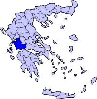
Aitolia-Acarnania
|
|
| Statistics | |||
|---|---|---|---|
| Capital: | Messolonghi | ||
| Peripheries | West Greece <TR valign=top> | Area: | 5,447 km² Ranked 1st |
| Inhabitants: | (1991), 230,688(2001) | ||
| Pop. density: | inh./km² 2001 | ||
| ISO 3166-2: | GR-01 | ||
| Name of inhabitants | Aitolo-Acarnanians | ||
| Code for municipalities | 02xx | ||
| Number of provinces | 5 | ||
| Number of municipalities | 27 | ||
| Area codes in Greece: | 11+30-263x0 11+30-264x0 | ||
| Car designation | AI, Aetolia (Aitolia) ME, Acarnania (Messolonghi) | ||
| Postal code: | 30x xx | ||
| Website: | www.aitoloakarnania.gr (in Greek) | ||
| Map | |||

| |||
Aitolia-Acarnania, (Greek: Αιτωλοακαρνανία) also Aetoloacarnania, rarely Aetolia and Acarnania or Aitoloakarnania is one of the fifty-one prefectures of Greece. It is located in the western part of Greece. The prefecture is a combination of Aetolia and Acarnania. Its capital is Messolongi located in the south. The area is now connected with the Peloponnese peninsula with Rio-Antirio bridge. The surrounding prefectures are Arta in Epirus, a narrow length bordering Karditsa of Thessaly, Evrytania/Eurytania to the northeast and Phokida (Phokis) to the east. It is the largest prefecture in area in Greece.
| Contents [hide] |
Geography
Mountains dominate the north, northeast, west and southeast especially the Acarnanian Mountains. The longest and main river is the Acheloos which ends as a delta in a wetlands in the southwest. The prefecture excludes islands lying in the west which belongs to the Kefallinia prefecture. There is one reservoir and a lake in the central part. Its mountains includes the Panaitoliko in the northeast and the Acarnanian Mountains where a spring water company was founded.
Climate
Its climate varies from hot summers to mild winters in the low lying areas, cool winters dominate the mountain areas while in the highest elevations, summers are cool and snow and cold weather dominate the winter months in the Panaitoliko.
Transportation
- Greece Interstate 5/E55, SE, S, Cen., N
- Greece Interstate 38, Cen., NE
- Greece Interstate 42, N, NW
- Greece Interstate 48/E65, SE
- Road linking Agios Nikolaos, Astakos and Aitoliko, NW, W, SW, S
Communications
Radio
Television
- Lychnos, UHF channel 32 (religious), broadcasting from Nafpaktos
- Nafpaktos TV - Nafpaktos
Newspapers
Provinces
- Province of Messolonghi - Messolonghi/Messolongi
- Province of Nafpaktia - Nafpaktos
- Province of Trichonida - Agrinio
- Province of Vonitsa and Xirokampi - Vonitsa
Municipalities
- Agrinio
- Aitoliko
- Alyzia - Kandyla
- Amfilochia
- Anaktorio - Vonitsa
- Angelokastro
- Antirrio
- Apodotia - Ano Chora
- Arakynthos - Pappadates
- Astakos
- Chalkia
- Fyties
- Iera Poli Messolongiou - Messolonghi
- Inacho - Neo Chalkiopoulo
- Kekropia - Paleros
- Makrynia - Gavalou
- Menidi
- Nafpaktos
- Neapoli - Trianteika
- Panaitoliko - Skoutera
- Parakampylia - Ano Agios Vlassios
- Paravola
- Platanos
- Pyllini - Simos
- Stratos
- Thermo
- Thespies
Towns and cities
- Agrinio
- Amfilochia
- Antirio
- Astakos
- Messolongi, sometimes Messolonghi (capital)
- Nafpaktos
- Vonitsa
Communities
Persons
- Giovas Vlachiotis, a person where he fought on the Greek side during the Greek War of Independence, he did not make it, his som Michail continued to fight against the Turks.
External links
- culture.gr on Aetoloacarnania (http://www.culture.gr/maps/sterea/aitakarn/aitakarn.html)
- Structurae on Aetoloacarnania (http://www.structurae.net/en/geo/geoid/11052/index.cfm)
