Uttaranchal
|
|
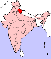
Uttaranchal (उत्तरांचल) became the 27th state of the Republic of India on November 9, 2000 after a relatively short and peaceful struggle by its people in the 1990s, having previously comprised part of Uttar Pradesh. Uttaranchal borders Tibet in the north-east and Nepal to the south-east, while its neighbour states are Himachal Pradesh and Uttar Pradesh. The provisional capital of Uttaranchal is Dehradun which is also a rail-head and largest city in the region. The small hamlet of Gairsain has been mooted as a future capital owing to its geographic centrality. The High Court of Uttaranchal is situated in the district of Nainital. The region is also known as Uttarakhand, which derives from the Sanskrit for North Country.
Uttaranchal has traditionally been divided into two parts, the western half known as Garhwal and the eastern region going by the name of Kumaon.
Uttaranchal is a region of outstanding natural beauty. Most of the northern parts of the state are covered by the high Himalayan ranges and glaciers, while the lower reaches are densely forested. The unique Himalayan ecosystem plays host to a large number of animals (including bharal, snow leopards, leopards and tigers), plants and rare herbs. Two of India's mightiest rivers, the Ganga and the Yamuna take birth in the glaciers of Uttaranchal, and are fed by myriad lakes, glacial melts and streams in the region.
The tourism industry is a major contributor to the economy of Uttaranchal, with the Raj era hill-stations at Mussoorie, Almora, Ranikhet and Nainital being some of the most frequented destinations. To this region also belong some of the holiest Hindu shrines, and for almost 2000 years now pilgrims have been visiting the temples at Haridwar, Rishikesh, Badrinath and Kedarnath in the hope of salvation and purification from sin.
Recent developments in the region include initiatives by the state government to capitalise on the burgeoning tourist trade. The state also plays host to some of the worst conceived big-dam projects in India such as the monstrously large Tehri dam on the Bhagirathi-Bhilangana rivers, conceived in 1953 and still incomplete.
| Contents |
People
The native people call themselves Garhwali/Kumaoni and majority of them are Hindus. Few segments of Kumaoni people also call themselves as Pahari. Other ethnic communities in the region include Nepalis who have arrived over the past century, the Jadh, Marcha and Shauka on the Indo-Tibetan frontier, collectively known as the Bhotiya, and nomadic cattle herders known as Gujjar in the southern Terai region.
The Tharu and Buksha can also be found in the hilly Terai region.
Geography
Uttaranchal lies on the south slope of the mighty Himalaya range, and the climate and vegetation vary greatly with elevation, from glaciers at the highest elevations to tropical forests at the lower elevations. The highest elevations are covered by ice and bare rock. The Western Himalayan Alpine Shrub and Meadows ecoregion lies between 3000-3500 and 5000 meters elevation; tundra and alpine meadows cover the highest elevations, transitioning to Rhododendron-dominated shrublands below. The Western Himalayan subalpine conifer forests lie just below the tree line; at 3000-2600 meters elevation they transition to the Western Himalayan broadleaf forests, which lie in a belt from 2,600 to 1,500 meters elevation. Below 1500 meters elevation lies western end of the drier Terai-Duar savanna and grasslands belt, and the Upper Gangetic Plains moist deciduous forests. This belt is locally known as Bhabhar.These lowland forests have mostly been cleared for agriculture, but a few pockets remain.
Indian National Parks in Uttaranchal include the Valley of Flowers National Park and Nanda Devi National Park in Chamoli District, Jim Corbett National Park in Nainital District, Rajaji National Park in Haridwar District, and Govind Pashu Vihar National Park and Gangotri National Park in Uttarkashi District.
Statistics
- Total Geographical area: 51,125 km²
- Hill Area: 92.57%
- Plain Area: 7.43%
- Area Covered By Forest: 63%
- Location
- Longitude 77° 34' 27" East to 81° 02' 22" E
- Latitude 28° 53' 24" North to 31° 27' 50" N
- Total Population: 7,050,634 (Male : Female = 1000 : 976)
- Male: % 51.91
- Female: % 48.81
- Rural Population: 76.90 %
- Urban Population: 23.10 %
- Other Minorities: 2.0 %(approx)
- Literacy Rate: 65%
- Villages: 15620
- Cities and Urban Areas: 81
- Railway Stations: Kotwara, Dehradun, Haridwar, Rishikesh, Haldwani, Lalkuan, Kathgodam, Tanakpur
- Airports: Pant Nagar, Nainisaine, Jolly Grant
- Major Peaks (height in m above sea level)
- Gauri Parvat (6590), Gangotri (6614), Panch Chhuli( 6910), Nanda Devi (7816), Nanda Kot (6861), Kamet( 7756), Badrinath (7140), Trishul (7120), Chaukhamba (7138), Dunagiri (7066)
- Major Passes
- Mana (5450), Nitipass (5070), Lipulekh( 5122), LumpiaDhura (5650)
- Industry
- Tourism, Dairy, Agriculture, Horticulture, Floriculture, Sugar and other small scale industries
- Festivals
- Uttarani, Nanda Devi Mela, Holi, Diwali, Dasara, Kandali, Hilljatra, Bikhoti, Bagwal, Harela, Ghugutee
- Events
- Sardotasv, Basantotsav, Nanda Devi Raj Jat, Chipla Kedar Jaat, Kedarnath Yatra, Badrinath Yatra, Kumbh Mela, Ardh Kumbh Mela, Ramleela
- Trade Centers
- Haldwani, Rudrapur, Tanakpur, Dehradun, Haridwar, Kotdwar, Rishikesh
Districts
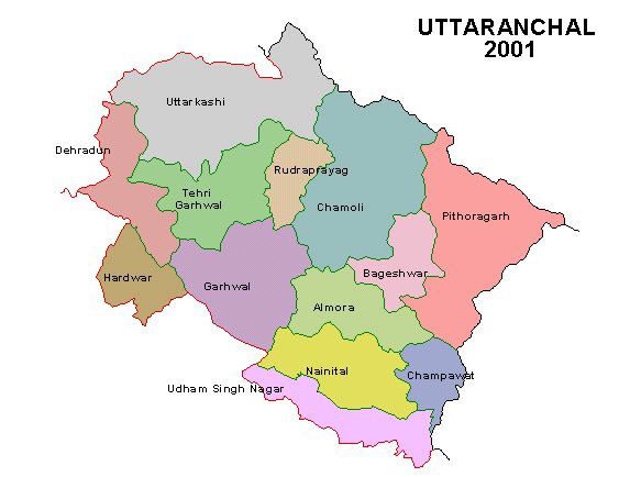
Uttaranchal is divided into 13 districts: Almora, Bageshwar, Chamoli, Champawat, Dehradun, Haridwar, Nainital, Pauri (Pauri Garhwal), Pithoragarh, Rudraprayag, Tehri (Tehri Garhwal), Udham Singh Nagar, and Uttarkashi. These districts form two divisions; Garhwal division includes Chamoli, Dehradun, Haridwar, Pauri Garhwal, Rudraprayag, Tehri, and Uttarkashi districts, and Kumaon division includes Almora, Bageshwar, Champawat, Nainital, Pithoragarh, and Udham Singh Nagar.
Template:Indiade:Uttaranchal
fr:Uttaranchal
hi:उत्तरांचल
nl:Uttaranchal
pt:Uttaranchal
sv:Uttaranchal
zh:乌塔兰契尔邦


