
Louisiana
|
|
| ||||||||||||||||||||||||||||||||||||||||||||||||||||||||||||||||
| ||||||||||||||||||||||||||||||||||||||||||||||||||||||||||||||||


Louisiana is a Southern state of the United States of America. It uses the U.S. postal abbreviation LA. The state is bordered to the west by the state of Texas, to the north by Arkansas, to the east by the state of Mississippi, and to the south by the Gulf of Mexico. Among the states, Louisiana has a unique culture, owing to its French colonial heritage. While the state has no declared "official language", its law recognizes both English and French. Today, English is by far the main language of everyday life, but traces of French survive in local dialects.
| Contents |
History
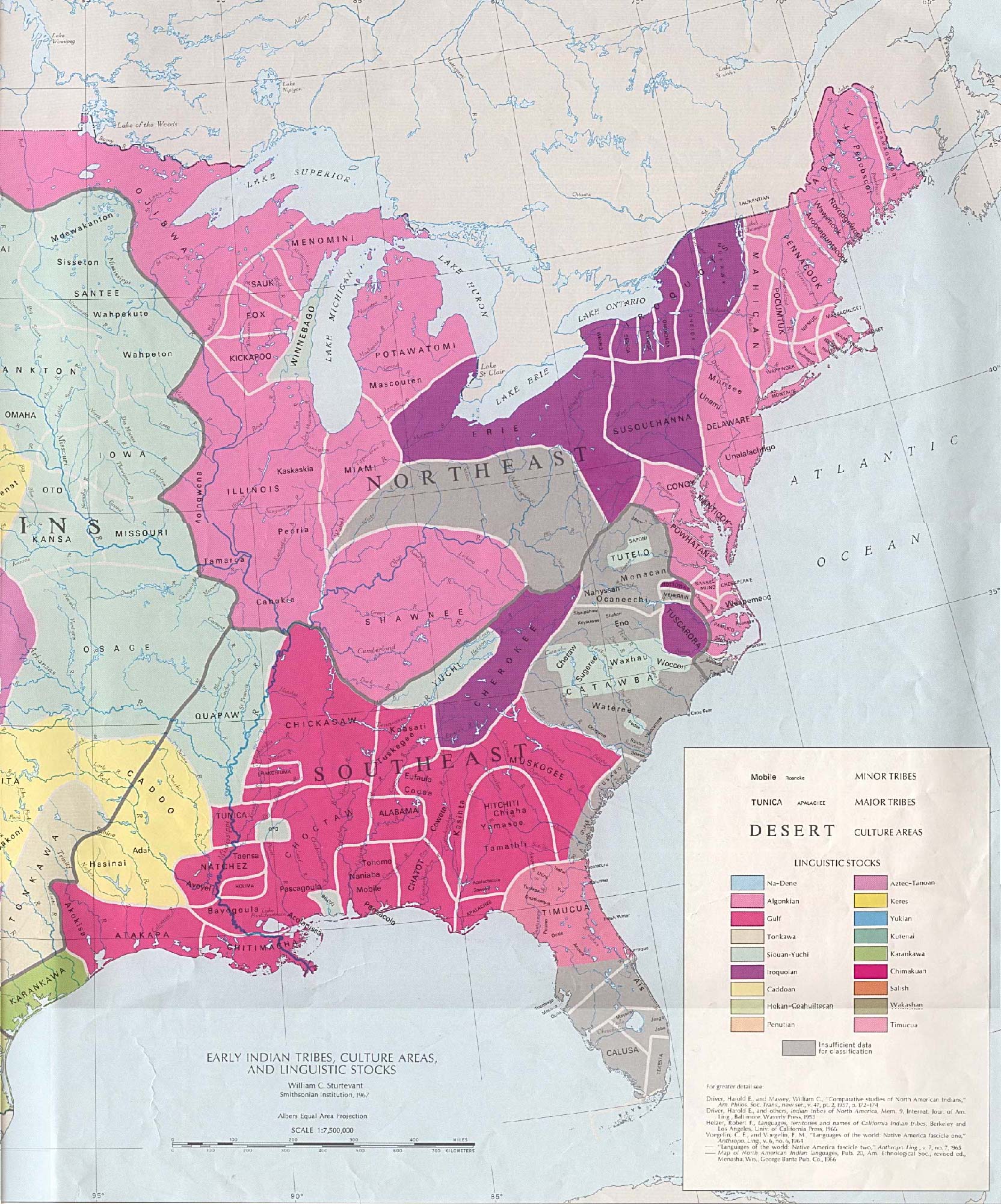
Louisiana was long inhabited by Native American tribes before the arrival of Europeans. The lasting mark of the Native Americans can be seen even today in the names used in Louisiana, such as Atchafalaya, Natchitouches (now spelled Natchitoches), Caddo, Houma, Tangipahoa, and Avoyel (Avoyelles Parish).
What follows is a partial list, using current parish boundaries as rough approximations of locations.Template:Ref
- The Atakapa were found in southwestern Louisiana in the parishes of Vermilion, Cameron, Lafayette, Acadia, Jefferson Davis, and Calcasieu.
- The Chitimachas occupied the southeastern parishes of Iberia, Assumption, St Mary, Lower St. Martin, Terrebone, LaFourche, St. James, St. John the Baptist, St.Bo St. Charles, Jefferson, Orleans, St. Bernard, and Plaquemines.
- The Bayougoula, part of the Choctaw nation, were found in points directly north of the Chitimachas, in the parishes of St. Helena, Tangipahoa, Washington, East and West Baton Rouge, Livingston, and St. Tammany.
- The Houma tribe, was found in East and West Feliciana, and Pointe Coupee parishes; Ironically about 100 miles north of current location of the town named after them.
- Portions of Avoyelles and Concordia parishes along the Mississippi River were home to the Avoyel, part of the Natchez nation.
- The northeastern parishes of Tensas, Madison, and East and West Carroll were occupied by the Tunica tribe.
- The remainder of current day central and north Louisiana was home to a substantial portion of the Caddo nation.
The first European explorers to visit what is now Louisiana was a Spanish expedition in 1528 led by Panfilo de Narv which located the mouth of the Mississippi River. Some 13 years later Hernando de Soto's expedition crossed through the region. Thereafter the region was long neglected by the Spanish authorities, and the next explorers were French. Louisiana was named by the French explorer Robert Cavelier de La Salle in honour of Louis XIV in 1682. The first permanent settlement was founded by Pierre Le Moyne d'Iberville in 1699.
The French colony of Louisiana originally claimed a great region of land on both sides of the Mississippi River and north to Canada. Most of the settlement concentrated along the banks of the Mississippi and its major tributaries, with trading outposts and mission settlements in the Illinois Country, as far north as Peoria, Illinois and a number of settlements in the area around near present-day Saint Louis, Missouri. See also: French colonization of the Americas
Initially Mobile, Alabama and Biloxi, Mississippi functioned as the capital of the colony; from 1722 on New Orleans fulfilled that role.
Most of the territory to the east of the Mississippi was lost to Great Britain in the French and Indian War, except for the area around New Orleans and the parishes around Lake Pontchartrain. The rest of Louisiana became a colony of Spain by the Treaty of Fountainebleau of 1762.
During the period of Spanish rule, several thousand French-speaking refugees from the region of Acadia made their way to Louisiana following British expulsion; settling largely in the southwestern bayous, they became known as the Cajuns.
In 1800 France's Napoleon Bonaparte re-acquired Louisiana from Spain in the Treaty of San Ildefonso, although this was kept secret for some two years.
In 1803 the United States purchased the French province of Louisiana (see Louisiana Purchase) and divided it into two territories: the Orleans Territory (which became the state of Louisiana in 1812) and the District of Louisiana (which consisted of all the land not included in Orleans Territory). The Florida Parishes were annexed from Spanish West Florida by proclamation of President James Madison in 1810. The western boundary of Louisiana with Spanish Texas remained in dispute until the Adams-On�Treaty in 1819, with the Sabine Free State serving as a neutral buffer zone as well as a haven for criminals.
There are still remnants of its former status as a possession of France, including: the use of a civil law legal system, based on the Louisiana Civil Code, which is similar to (and often confused with) the Napoleonic Code (like France, and unlike the rest of the United States, which uses a common law legal system derived from England), the term "parishes" being used to describe the state's sub-divisions as opposed to "counties", etc.
In 1849 the capital moved from New Orleans to Baton Rouge. Donaldsonville, Opelousas, and Shreveport have also briefly served as the seat of governments of Louisiana.
In the American Civil War Louisiana seceded from the Union on January 26, 1861. New Orleans was captured by Federal troops on April 25, 1862. As significant portions of the population had Union sympathies, the Federal government took the unusual step of recognizing the areas of Louisiana under Federal control as a state within the Union with elected representatives who were sent to the congress in Washington, D.C. throughout the rest of the war.
Law and Government
The capital of Louisiana is Baton Rouge. Its governor is Kathleen Babineaux Blanco (Democrat) and its two U.S. senators are Mary Landrieu (Democrat) and David Vitter (Republican). Louisiana has seven U.S. Congressmen, five of which are Republicans, two of which are Democrats.
Louisiana is the only state whose legal system is based on Roman, Spanish, and French civil law as opposed to English common law. Technically, it is known as "Civil Law," or the "Civilian System." It is often incorrectly referred to as the "Code Napoleon" or The Napoleonic Code. It is important to note that the Louisiana Civil Code and the French Civil Code, often referred to as the Napoleonic Code, came into existence at roughly the same time. Louisiana was never governed by the Napoleonic Code.
Great differences still exist between Louisiana Civil Law and the Common Law found in her 49 sister states. While most of the differences are now found in verbiage, it is important to note that the "Civilian" tradition is still deeply rooted in all aspects of Louisiana law. Property, contractual, and family law are still mostly based on traditional Roman legal thinking and have little in common with English law.
Louisiana is unique among U.S. states in using a runoff in state, local, and congressional elections. All candidates run in an open primary on Election Day, in which multiple candidates from the same party may be on the ballot. If no candidate has more than 50% of the vote, the two candidates with the highest vote total compete in a runoff election approximately one month later. This runoff does not take into account party identification. Therefore it is common for a Democrat to be in a runoff with a fellow Democrat or a Republican to be in a runoff with a fellow Republican. All other states use the First Past the Post electoral system to elect Senators, Representatives, and statewide officials.
See: List of Louisiana Governors, Napoleon Bonaparte
Geography
National-atlas-louisiana.PNG
See: List of Louisiana parishes
Topography
The surface of the state may properly be divided into two parts, the uplands, and the alluvial and coast and swamp regions. The alluvial regions, including the low swamps and coast lands, cover an area of about 20,000 square miles; they lie principally along the Mississippi River, which traverses the state from north to south for a distance of about 600 miles and ultimately emptying into the Gulf of Mexico, the Red River, the Ouachita River and its branches, and other minor streams. The breadth of the alluvial region along the Mississippi is from 10 to 60 miles, and along the other streams it averages about 10 miles. The Mississippi flows upon a ridge formed by its own deposits, from which the lands incline toward the low swamps beyond at an average fall of six feet per mile. The lands along other streams present very similar features. These alluvial lands are never inundated save when breaks occur in the levees by which they are protected against the floods of the Mississippi and its tributaries. These floods, however, do not occur annually, and they may be said to be exceptional. With the maintenances of strong levees these alluvial lands would enjoy perpetual immunity from inundation. The uplands and contiguous hill lands have an area of more than 25,000 square miles, and they consist of prairie and woodlands. The elevations above sea-level range from 10 feet at the coast and swamp lands to 50 and 60 feet at the prairie and alluvial lands. In the uplands and hills the elevations rise to Mount Driskoll, the highest point in the state at only 535 feet above sea level, located in northwest Louisiana.
Besides the navigable rivers already named (some of which are called bayous), there are the Sabine, forming the western boundary, and the Pearl, the eastern boundary, the Calcasieu, the Mermentau, the Vermilion, the Teche, the Atchafalaya, the Boeuf, the Lafourche, the Courtableau, the D'Arbonne, the Macon, the Tensas, the Amite, the Tchefuncta, the Tickfaw, the Matalbany, and a number of other streams of lesser note, constituting a natural system of navigable waterways, aggregating over 4,000 miles in length, which is unequalled in the United States and probably in the world. The state also has 1,060 square miles of land-locked bays, 1,700 square miles of inland lakes, and a river surface of over 500 square miles.
Geology
The underlying strata of the state are of Cretaceous age and are covered by alluvial deposits of Tertiary and post-Tertiary origin. A large part of Louisiana is the creation and product of the Mississippi River. It was originally covered by an arm of the sea, and has been built up by the silt carried down the valley by the great river.
Near the coast, there are many salt domes, where salt is mined and oil is often found.
Owing to the extensive flood control measures along the Mississippi river and to natural subsidence, Louisiana is now suffering the loss of coastal land area. State and Federal government efforts to halt or reverse this phenomenon are under way; others are being sought.
Interstate highways
There are proposed plans to extend Interstate 69 to the Texas/Mexico border, which will go through north-eastern Louisiana. Also, Interstate 49 is slated to be expanded north into Arkansas and east along Interstate 10 to New Orleans, replacing part of U.S. Highway 90.
United States highways
| North-south routes | East-west routes |
Economy
The total gross state product in 2003 for Louisiana was $140 billion. Its Per Capita Personal Income was $26,312, 43rd in the nation. The state's principal agricultural outputs include seafood, cotton, soybeans, cattle, sugarcane, poultry and eggs, dairy products, and rice. Its industrial outputs include chemical products, petroleum and coal products, food processing, transportation equipment, paper products, and tourism.
Demographics
See also: List of famous people from Louisiana; List of Louisiana musicians; Music of Louisiana
|
As of 2003, the state's population was 4,496,334, including approximately 215,000 native French-speakers. The racial makeup of the state is:
The five largest ancestries in the state are: African American (32.5%), French/French Canadian (16.2%), American (10.1%), German (7.1%), Irish (7%). As of 2000, 91.2% of Louisiana residents age 5 and older speak English at home and 4.8% speak French. Spanish is the third most spoken language at 2.5%, followed by Vietnamese at 0.6% and German at 0.2%. |
ReligionThe religious affiliations of the people of Louisiana are:
The three largest Protestant denominations in Louisiana are: Baptist (29% of the total state population), Methodist (5%), Pentecostal (2%). |
Important cities and towns
|
|
Top 10 richest places in Louisiana
Ranked by per capita income
- Mound: $92,200 (population 12, as of the 2000 census)
- Oak Hills Place: $34,944
- Elmwood: $34,329
- Eden Isle: $31,798
- Gilliam: $30,264
- Shenandoah: $29,722
- Westminster: $28,087
- River Ridge: $27,088
- Prien: $26,537
- Mandeville: $26,420
- For more see the complete list of places
Education
For schools see List of school districts in Louisiana
Colleges and universities
Professional sports teams
Football
- National Football League
- Arena Football League
- Other football leagues
- New Orleans Spice - NWFL
- Shreveport Bombers - IPFL
- Louisiana Bayou Beast - IPFL
- Southwest Louisiana (Lake Charles) Swashbucklers - IPFL
- Bossier City Battle Wings - AF2
- Semi-Pro football Teams
- Baton Rouge Riverboat Bandits - SAFL
- Lake Charles RiverKats - SAFL
- Minden RoughRiders - SAFL
- Lafayette Bayou Bulls - SAFL
- Ruston Rage - SAFL
- Shreveport Steamers - SAFL
- Greater New Orleans Gladiators - SAFL
- Hammond Headhunters - SAFL
- Louisiana (Houma) Blazing Bulldogs - SAFL
- Central Louisiana Warriors - SAFL
- Slidell Steelsharks - SAFL
Baseball
- Minor League baseball teams
- New Orleans Zephyrs
- Shreveport Sports
- Alexandria Aces
- Baton Rouge River Bats
- Houma Hawks
- New Orleans Pelicans (1887-1959)
- New Orleans Creoles (Negro League) (dates?)
Basketball
- National Basketball Association:
- New Orleans Jazz (1974) team moved to Salt Lake City and became the Utah Jazz in 1979
- The Charlotte Hornets moved to New Orleans in 2002 - Now known as The New Orleans Hornets.
Hockey
- Minor League Hockey
- New Orleans Brass (1997 - 2003) - ECHL
- Louisiana IceGators - ECHL
- Bossier-Shreveport Mudbugs - CHL
Miscellaneous information
- State dog : Catahoula Leopard Dog
- State bird : Eastern Brown Pelican
- State flower : Magnolia
- State fossil : Petrified palmwood
- State tree : Bald Cypress
- State mammal : Louisiana Black Bear
- State wildflower : Louisiana Iris
- State reptile : American Alligator
- State insect: Honeybee
- State crustacean : Crawfish
- State amphibian: Green Tree Frog
- State food: Gumbo
- State songs: You Are My Sunshine, Every Man a King, and Give Me Louisiana
Two separate historically Francophone communities exist in Louisiana.
- The ancestors of Creoles generally came to Louisiana directly from France or from the French colonies in the Caribbean and settled in New Orleans or in South Eastern Louisiana.
- The ancestors of the Cajuns are the Acadians, a French-descended people of what are now New Brunswick and Nova Scotia, Canada. When the British won the French and Indian War, the British forced all of the citizens to take a pledge of allegiance. Most Acadians declined and emigrated from Canada, most of them fleeing to the South Western portion of Louisiana, centered in the region around Lafayette.
There is also a distinct Spanish-descended group in Louisiana. The Islenos are dirrect descendants of Canary Islanders forced to migrate by the Spanish King beginning in the mid-1770s. There were intended to help guard the eastern approaches to New Orleans from invasion by the British. They settled in what is modern-day St. Bernard Parish, in the river passes east of the city, along an old mouth of the Mississippi River which they named Terre Aux Bouefs (literally "Land of the Cows" for the cattle living there). Many of their descendants remained insulated from the city, and continued to speak an archaic version of Spanish well into the 20th Century. They still maintain contacts with the Canary Islands, and have an annual "Caldo" festival named for a native dish.
For almost 20 years there was only one amusement park in Louisiana, called Hamel's Amusement Park near Bossier City. There is now a Six Flags in New Orleans East.
Slavery and Louisiana.
- Louisiana was a slave state. It did, however, have one of the largest free black populations in the United States. While one would think that this would lead to a dramatic reduction in the amount of slavery in the state, this is not the case. Many of the freed slaves in Louisiana in turn purchased their own slaves, which led to the state having one of the largest numbers of slave owning blacks in America, if not the largest.
References
- Template:NoteSturdevent, William C. (1967): Early Indian Tribes, Cultures, and Linguistic Stocks (http://www.lib.utexas.edu/maps/united_states/early_indian_east.jpg), Smithsonian Institution Map (Eastern United States).
See also
Clip Art and Pictures
- Free Clipart (http://classroomclipart.com)
State Maps
- US State Maps (http://classroomclipart.com/cgi-bin/kids/imageFolio.cgi?direct=Clipart/US_State_Maps)
- Printable Black and White Map of Louisiana (http://www.lessonplancentral.com/statemaps/louisiana_mapBW.htm)
State Flags
- US State Flags (http://classroomclipart.com/cgi-bin/kids/imageFolio.cgi?direct=Clipart/State_Flags)
Lesson Plans, Resources and Activites
- Lesson Plan Central (http://lessonplancentral.com)
External links
- Official State of Louisiana website (http://www.state.la.us)
- US Census Bureau (http://quickfacts.census.gov/qfd/states/22000.html)
- Photos of Louisiana - Terra Galleria (http://www.terragalleria.com/america/south-east/louisiana)
| Political divisions of the United States | 
| ||||||
|---|---|---|---|---|---|---|---|
| |||||||